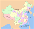
File:Map of PRC with province names zh-cn.svg
外观

此SVG文件的PNG预览的大小:713 × 599像素。 其他分辨率:286 × 240像素 | 571 × 480像素 | 914 × 768像素 | 1,218 × 1,024像素 | 2,436 × 2,048像素 | 1,217 × 1,023像素。
原始文件 (SVG文件,尺寸为1,217 × 1,023像素,文件大小:1.02 MB)
文件历史
点击某个日期/时间查看对应时刻的文件。
| 日期/时间 | 缩略图 | 大小 | 用户 | 备注 | |
|---|---|---|---|---|---|
| 当前 | 2011年10月4日 (二) 21:30 |  | 1,217 × 1,023(1.02 MB) | Ras67 | cropped |
| 2010年7月1日 (四) 17:33 |  | 1,223 × 1,029(1.31 MB) | DieBucheBot | Trying to fix SVG using scour | |
| 2007年11月6日 (二) 05:10 |  | 1,223 × 1,029(1.37 MB) | PhiLiP | ||
| 2007年11月5日 (一) 12:47 |  | 1,223 × 1,029(1.39 MB) | PhiLiP | ||
| 2007年11月5日 (一) 12:30 |  | 1,223 × 1,029(1.39 MB) | PhiLiP | == Summary == {{Information |Description= {{zh-cn|中华人民共和国地图,显示有省级行政区名称。}} {{en|A map of the People Republic of China, with province names. }} |Source=Created by User:PhiLiP, based on some bitmap files. |Date=N |
文件用途
以下2个页面使用本文件:
全域文件用途
以下其他wiki使用此文件:
- zh-classical.wikipedia.org上的用途
- zh.wikivoyage.org上的用途


