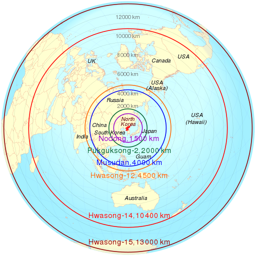
File:North Korean missile range.svg
外观

此SVG文件的PNG预览的大小:512 × 512像素。 其他分辨率:240 × 240像素 | 480 × 480像素 | 768 × 768像素 | 1,024 × 1,024像素 | 2,048 × 2,048像素。
原始文件 (SVG文件,尺寸为512 × 512像素,文件大小:163 KB)
文件历史
点击某个日期/时间查看对应时刻的文件。
| 日期/时间 | 缩略图 | 大小 | 用户 | 备注 | |
|---|---|---|---|---|---|
| 当前 | 2022年2月3日 (四) 08:14 |  | 512 × 512(163 KB) | Cmglee | Update as per http://bbc.com/news/world-asia-60193714#Advances-in-N-Koreas-missile-technology |
| 2017年7月5日 (三) 17:25 |  | 512 × 512(163 KB) | Cmglee | Update Hwasong/KN-14 range. | |
| 2017年5月19日 (五) 18:01 |  | 512 × 512(162 KB) | Cmglee | Add KN-08 and KN-14 from http://bbc.com/news/world-asia-17399847 | |
| 2017年5月11日 (四) 06:12 |  | 512 × 512(162 KB) | Cmglee | Update ranges and map to azimuthal equidistant projection. | |
| 2013年4月4日 (四) 18:26 |  | 512 × 512(688 KB) | Cmglee | Label Koreas. | |
| 2013年4月4日 (四) 12:52 |  | 512 × 512(688 KB) | Cmglee | Add Guam and Hawaii. | |
| 2013年4月4日 (四) 12:28 |  | 512 × 512(688 KB) | Cmglee | == {{int:filedesc}} == {{Information |Description={{de|Lage von XY (siehe Dateiname) auf der Erde.}} {{en|Location of XY (see filename) on the globe.}} |Source={{Derived from|North_Korea_on_the_globe_(Japan_centered).svg|disp... |
文件用途
以下7个页面使用本文件:
全域文件用途
以下其他wiki使用此文件:
- ar.wikipedia.org上的用途
- ast.wikipedia.org上的用途
- bg.wikipedia.org上的用途
- ca.wikipedia.org上的用途
- de.wikipedia.org上的用途
- en.wikipedia.org上的用途
- North Korea and weapons of mass destruction
- Hwasong-7
- Azimuthal equidistant projection
- User:Cmglee
- Korean People's Army Strategic Force
- Hwasong-10
- 2013 in North Korea
- User:Cmglee/svg
- Wikipedia:Miscellany for deletion/User:B3430715/Userboxes/privacy
- Hwasong-12
- 2018 Hawaii false missile alert
- Aegis system equipped vessels (ASEV)
- en.wikiquote.org上的用途
- es.wikipedia.org上的用途
- es.wikinews.org上的用途
- fa.wikipedia.org上的用途
- fi.wikipedia.org上的用途
- fr.wikipedia.org上的用途
- it.wikipedia.org上的用途
- ja.wikipedia.org上的用途
- ko.wikipedia.org上的用途
- nl.wikipedia.org上的用途
- no.wikipedia.org上的用途
- pl.wikipedia.org上的用途
- pt.wikipedia.org上的用途
- ru.wikipedia.org上的用途
查看此文件的更多全域用途。


