跳转到内容

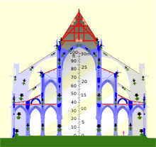
File:Notre-Dame de Paris composite transverse section.svg

页面内容不支持其他语言。
這個文件來自維基共享資源
维基百科,自由的百科全书

原始文件 (SVG文件,尺寸为856 × 1,494像素,文件大小:407 KB)


摘要

描述
English: Composite transverse section of Notre-Dame de Paris before the 2019 fire. Timber framework in red, masonry in blues, metal in grey. Left, a tower, showing internal framework of belfry (bells not shown). Center, nave, covered by masonry vault and 55-degree triangular roof (spire shown above and behind). Right, side aisles, triforium aisle above, flying buttresses. Note that the vaults thrust outwards on the walls, and the flying buttresses thrust inwards; unless these two forces balance, the wall will be pushed over. Black arrows show the force of the weight of the structure being transmitted to the ground; green arrows show the upwards force of the ground supporting the structure. Orange and grey arrows show the forces in the wood and metal of the roof trusses. Roof trusses cancel out their outwards forces using internal tension (masonry cannot support tension). Light added for clarity.
日期
来源 Own work, derived as indicated under "authors"
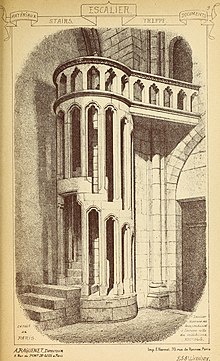
作者 Own work, traced from public domain File:Notre Dame 531 transverse crop rot.jpg and heavily altered, mostly using the public domain architectural drawings of Eugène Viollet-le-Duc (see particularly Category:Frame of Notre-Dame de Paris). The public-domain image File:Materials and documents of architecture and sculpture - classified alphabetically (1915) (14587788087).jpg was used for the stair. Photos were also used to verify details; thanks to all Commons contributors who took unconventional shots.
其他版本
non-composite cross-section
相机位置48° 51′ 10.8″ 北, 2° 20′ 59.28″ 东  Heading=135° Kartographer map based on OpenStreetMap.在以下服务上查看本图像和附近其他图像: OpenStreetMapinfo

Please note that this is not a finite element analysis, nor yet an architectural drawing; it's an infographic. That said, corrections are welcome. There are probably errors; I honestly have no good data on the space between the the vaults and the floors, for instance, and no idea if the area between the towers is even flat. I've made guesses, which I hope are sensible ones. The crypt, foundations, and staircase in the belfry framing are not shows due to lack of data. The North tower is shown with the framing of the south tower, due to a lack of an elevation of the latter. There are eight bells in the north tower, but from this perspective four bells are hiding behind the other four. I do not know which bells are larger and have not attempted to show the size range.

许可协议

w:zh:知识共享
署名 相同方式共享
本文件采用知识共享署名-相同方式共享 4.0 国际许可协议授权。
您可以自由地:
  • 共享 – 复制、发行并传播本作品
  • 修改 – 改编作品
惟须遵守下列条件:
  • 署名 – 您必须对作品进行署名,提供授权条款的链接,并说明是否对原始内容进行了更改。您可以用任何合理的方式来署名,但不得以任何方式表明许可人认可您或您的使用。
  • 相同方式共享 – 如果您再混合、转换或者基于本作品进行创作,您必须以与原先许可协议相同或相兼容的许可协议分发您贡献的作品。
註解
InfoField
該圖片含有註解:在維基媒體共享資源上查看註解

说明

添加一行文字以描述该文件所表现的内容
Composite transverse section of Notre-Dame de Paris

此文件中描述的项目

描繪內容

48°51'10.8"N, 2°20'59.3"E

相机朝向 简体中文(已转写):​135 角度

image/svg+xml

文件历史

点击某个日期/时间查看对应时刻的文件。

日期/时间缩⁠略⁠图大小用户备注
当前2020年3月6日 (五) 01:302020年3月6日 (五) 01:30版本的缩略图856 × 1,494(407 KB)HLHJPut the rafters of the tower in compression. Not sure how I missed that.
2019年7月30日 (二) 01:492019年7月30日 (二) 01:49版本的缩略图856 × 1,494(408 KB)HLHJBells roughed in, positions researched from [https://www.nytimes.com/interactive/2019/07/16/world/europe/notre-dame.html NYT infographic model]. Note that the framework shown for the North Tower is that of the South Tower, as no elevation drawing of the north belltower framework seems to be available on Commons (please let me know if you find one).
2019年5月18日 (六) 17:082019年5月18日 (六) 17:08版本的缩略图856 × 1,494(394 KB)HLHJUser created page with UploadWizard

以下页面使用本文件:

全域文件用途

以下其他wiki使用此文件:

元数据