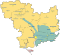
File:Russian Occupation of Mykolaiv Oblast.svg
外观

此SVG文件的PNG预览的大小:651 × 599像素。 其他分辨率:261 × 240像素 | 521 × 480像素 | 834 × 768像素 | 1,112 × 1,024像素 | 2,225 × 2,048像素 | 1,209 × 1,113像素。
原始文件 (SVG文件,尺寸为1,209 × 1,113像素,文件大小:114 KB)
文件历史
点击某个日期/时间查看对应时刻的文件。
| 日期/时间 | 缩略图 | 大小 | 用户 | 备注 | |
|---|---|---|---|---|---|
| 当前 | 2024年12月27日 (五) 02:42 |  | 1,209 × 1,113(114 KB) | Physeters | add towns |
| 2022年11月11日 (五) 15:53 |  | 1,134 × 1,043(107 KB) | Basque mapping | Update per https://liveuamap.com/ | |
| 2022年11月11日 (五) 01:02 |  | 1,134 × 1,043(107 KB) | DinoSoupCanada | Reverted to version as of 00:47, 11 November 2022 (UTC) | |
| 2022年11月11日 (五) 01:01 |  | 2,497 × 2,458(1.27 MB) | DinoSoupCanada | Update | |
| 2022年11月11日 (五) 00:47 |  | 1,134 × 1,043(107 KB) | Physeters | Reverted to version as of 00:29, 11 November 2022 (UTC) Good faith edit, but as of Thursday evening, there is no confirmation that the Russians have completely withdrawn from this part of Mykolaiv Oblast | |
| 2022年11月11日 (五) 00:32 |  | 1,134 × 1,043(106 KB) | Timetorockknowlege | Updated to reflect the withdrawal from the Oblast with the exception of Vasylivka east of the Dnipro | |
| 2022年11月11日 (五) 00:29 |  | 1,134 × 1,043(107 KB) | Physeters | Updates per ISW | |
| 2022年11月10日 (四) 00:16 |  | 1,134 × 1,043(108 KB) | Physeters | Updates per the ISW & detailed map | |
| 2022年10月8日 (六) 04:39 |  | 1,134 × 1,043(107 KB) | Physeters | small update per ISW | |
| 2022年10月4日 (二) 00:47 |  | 1,134 × 1,043(107 KB) | Physeters | add Pervomaiske |
文件用途
以下页面使用本文件:
全域文件用途
以下其他wiki使用此文件:
- be.wikipedia.org上的用途
- en.wikipedia.org上的用途
- es.wikipedia.org上的用途
- fr.wikipedia.org上的用途
- id.wikipedia.org上的用途
- ja.wikipedia.org上的用途
- ko.wikipedia.org上的用途
- lv.wikipedia.org上的用途
- ru.wikipedia.org上的用途
- uk.wikipedia.org上的用途
- www.wikidata.org上的用途


