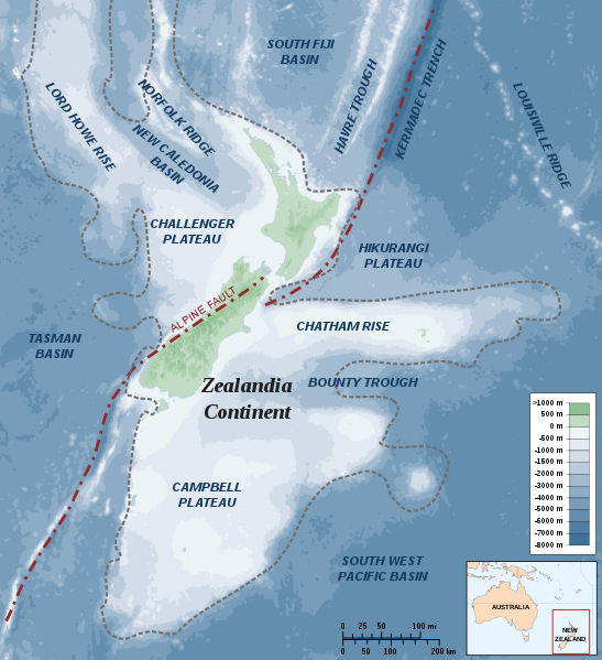
File:Zealandia-Continent map en.svg
外观

此SVG文件的PNG预览的大小:547 × 599像素。 其他分辨率:219 × 240像素 | 438 × 480像素 | 701 × 768像素 | 935 × 1,024像素 | 1,870 × 2,048像素 | 789 × 864像素。
原始文件 (SVG文件,尺寸为789 × 864像素,文件大小:327 KB)
文件历史
点击某个日期/时间查看对应时刻的文件。
| 日期/时间 | 缩略图 | 大小 | 用户 | 备注 | |
|---|---|---|---|---|---|
| 当前 | 2010年7月19日 (一) 22:37 |  | 789 × 864(327 KB) | Beao | Removed border. |
| 2009年6月1日 (一) 11:59 |  | 797 × 871(375 KB) | Alexrk | Removed Grid | |
| 2008年1月20日 (日) 14:19 |  | 797 × 871(380 KB) | Alexrk | ||
| 2008年1月20日 (日) 14:10 |  | 797 × 871(380 KB) | Alexrk | ||
| 2008年1月19日 (六) 16:44 |  | 797 × 871(380 KB) | Alexrk | ||
| 2008年1月19日 (六) 15:55 |  | 797 × 871(380 KB) | Alexrk | ||
| 2008年1月19日 (六) 15:52 |  | 1,000 × 1,000(380 KB) | Alexrk | == Summary == {{Information |Description=Map of the Zealandia Continent |Source=Own work<br/>Bathymetry: ETOPO2v2 2min - vectorized with Inkscape, Land Information New Zealand, Te Ara The Encyclopedia of New Zealand |Date=Jan 2008 |Date=J |
文件用途
全域文件用途
以下其他wiki使用此文件:
- af.wikipedia.org上的用途
- ang.wikipedia.org上的用途
- ast.wikipedia.org上的用途
- ca.wikipedia.org上的用途
- ceb.wikipedia.org上的用途
- cs.wikipedia.org上的用途
- de.wikipedia.org上的用途
- en.wikipedia.org上的用途
- Geography of New Zealand
- Hikurangi Trough
- Alpine Fault
- Portal:New Zealand
- Metanephrops challengeri
- User:Epipelagic/sandbox/sources
- Volcanism of New Zealand
- Hikurangi Plateau
- Puysegur Trench
- Talk:Zealandia
- Fishing industry in New Zealand
- Geology of New Zealand
- List of submarine topographical features
- Wikipedia:Reference desk/Archives/Science/2015 May 26
- eo.wikipedia.org上的用途
- es.wikipedia.org上的用途
- hi.wikipedia.org上的用途
- hu.wikipedia.org上的用途
- hy.wikipedia.org上的用途
- id.wikipedia.org上的用途
- incubator.wikimedia.org上的用途
- it.wikipedia.org上的用途
- ja.wikipedia.org上的用途
- ka.wikipedia.org上的用途
查看此文件的更多全域用途。


