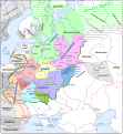
File:Kievan Rus in 1237 (en).svg
外觀

此 SVG 檔案的 PNG 預覽的大小:553 × 600 像素。 其他解析度:221 × 240 像素 | 442 × 480 像素 | 708 × 768 像素 | 944 × 1,024 像素 | 1,888 × 2,048 像素 | 1,204 × 1,306 像素。
原始檔案 (SVG 檔案,表面大小:1,204 × 1,306 像素,檔案大小:332 KB)
檔案歷史
點選日期/時間以檢視該時間的檔案版本。
| 日期/時間 | 縮圖 | 尺寸 | 使用者 | 備註 | |
|---|---|---|---|---|---|
| 目前 | 2021年9月25日 (六) 08:06 |  | 1,204 × 1,306(332 KB) | Veverve | "Khvalisy" changed to to "Khvalis" |
| 2021年4月9日 (五) 19:16 |  | 1,204 × 1,306(360 KB) | Veverve | "Principalty of Vladimir-Suzdal" corrected to "Principality of Vladimir-Suzdal" | |
| 2020年5月16日 (六) 17:04 |  | 1,204 × 1,306(360 KB) | Goran tek-en | Named changed as requested by user:Veverve | |
| 2020年2月12日 (三) 17:39 |  | 1,204 × 1,306(318 KB) | Goran tek-en | Changed name of Vladimir as requested bu Veverve | |
| 2020年2月12日 (三) 16:59 |  | 1,204 × 1,306(317 KB) | Goran tek-en | {{Information |description ={{en|1=Map of the Kievan Rus in 1237. The nales of tribes and peoples are in brown, the names of countries outside the Kievan Rus are in black. The names of principalties of the Kievan Rus are in blue; if a principalty bears the a name which comes directly from the name of its capital (e.g. the Principalty of Kiev), the complete name of the paincipalty is not on the map and the capital name is in blue.}} |date =20200212 |source ={{Own}}<br>... |
檔案用途
沒有使用此檔案的頁面。
全域檔案使用狀況
以下其他 wiki 使用了這個檔案:
- be.wikipedia.org 的使用狀況
- bg.wikipedia.org 的使用狀況
- ca.wikipedia.org 的使用狀況
- cy.wikipedia.org 的使用狀況
- da.wikipedia.org 的使用狀況
- de.wikipedia.org 的使用狀況
- en.wikipedia.org 的使用狀況
- es.wikipedia.org 的使用狀況
- hy.wikipedia.org 的使用狀況
- it.wikipedia.org 的使用狀況
- ja.wikipedia.org 的使用狀況
- ko.wikipedia.org 的使用狀況
- la.wikipedia.org 的使用狀況
- nl.wikipedia.org 的使用狀況
- nn.wikipedia.org 的使用狀況
- no.wikipedia.org 的使用狀況
- pt.wikipedia.org 的使用狀況
- ro.wikipedia.org 的使用狀況
- rue.wikipedia.org 的使用狀況
- ru.wikipedia.org 的使用狀況
- sw.wikipedia.org 的使用狀況
- tt.wikipedia.org 的使用狀況
- uk.wikipedia.org 的使用狀況
- www.wikidata.org 的使用狀況
檢視此檔案的更多全域使用狀況。


