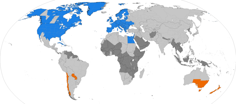
File:DST Countries Map.png
外觀

預覽大小:800 × 355 像素。 其他解析度:320 × 142 像素 | 640 × 284 像素 | 1,024 × 454 像素 | 1,280 × 568 像素 | 2,560 × 1,136 像素 | 4,952 × 2,197 像素。
原始檔案 (4,952 × 2,197 像素,檔案大小:462 KB,MIME 類型:image/png)
檔案歷史
點選日期/時間以檢視該時間的檔案版本。
| 日期/時間 | 縮圖 | 尺寸 | 用戶 | 備註 | |
|---|---|---|---|---|---|
| 目前 | 2024年10月15日 (二) 00:30 |  | 4,952 × 2,197(462 KB) | Heitordp | Updated Paraguay |
| 2024年3月31日 (日) 06:06 |  | 4,952 × 2,197(462 KB) | Heitordp | Adjusted Greenland | |
| 2023年12月31日 (日) 11:27 |  | 4,952 × 2,197(462 KB) | Heitordp | Updated Greenland, disputed borders, subdivisions of France, Morocco, DR Congo, South Sudan, Ethiopia, Somalia, India | |
| 2023年4月23日 (日) 09:44 |  | 4,952 × 2,197(463 KB) | Heitordp | Updated Ukraine | |
| 2023年4月5日 (三) 21:51 |  | 4,952 × 2,197(463 KB) | Heitordp | Updated most of Greenland, law specifies UTC–2 with no DST in 2023 | |
| 2023年3月27日 (一) 13:30 |  | 4,952 × 2,197(462 KB) | Heitordp | Corrected northeast Greenland and Qikiqtaaluk island | |
| 2023年3月1日 (三) 20:58 |  | 4,952 × 2,197(462 KB) | Heitordp | Updated Egypt, adjusted Kazakhstan | |
| 2022年11月30日 (三) 06:48 |  | 4,952 × 2,197(462 KB) | Heitordp | Updated Mexico | |
| 2022年11月20日 (日) 08:01 |  | 4,952 × 2,197(462 KB) | Heitordp | Removed Antarctica, added globe outline | |
| 2022年10月30日 (日) 09:29 |  | 4,972 × 2,492(466 KB) | Heitordp | Updated Mexico; adjusted US, Canada, Greenland |
檔案用途
下列3個頁面有用到此檔案:
全域檔案使用狀況
以下其他 wiki 使用了這個檔案:
- ar.wikipedia.org 的使用狀況
- azb.wikipedia.org 的使用狀況
- bs.wikipedia.org 的使用狀況
- en.wikipedia.org 的使用狀況
- es.wikipedia.org 的使用狀況
- fa.wikipedia.org 的使用狀況
- ga.wikipedia.org 的使用狀況
- hu.wikipedia.org 的使用狀況
- hy.wikipedia.org 的使用狀況
- ja.wikipedia.org 的使用狀況
- lo.wikipedia.org 的使用狀況
- lt.wikipedia.org 的使用狀況
- pnb.wikipedia.org 的使用狀況
- ru.wikipedia.org 的使用狀況
- sh.wikipedia.org 的使用狀況
- simple.wikipedia.org 的使用狀況
- sq.wikipedia.org 的使用狀況
- sr.wikipedia.org 的使用狀況
- ta.wikipedia.org 的使用狀況
- th.wikipedia.org 的使用狀況
- tr.wikipedia.org 的使用狀況
- vi.wikipedia.org 的使用狀況


