
File:Hurricane Erika 2003 Radar.jpg
此為最大尺寸。
Hurricane_Erika_2003_Radar.jpg (700 × 554 像素,檔案大小:376 KB,MIME 類型:image/jpeg)
摘要
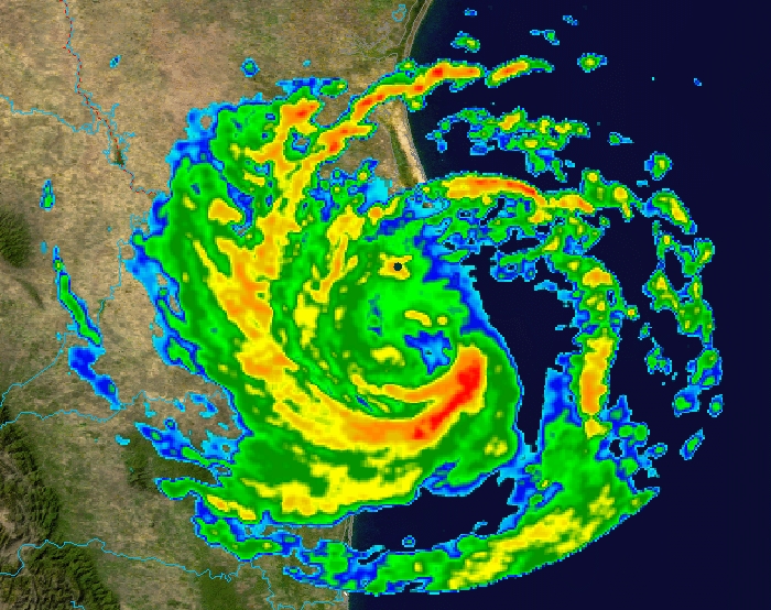
| 描述 | This image shows Hurricane Erika at 4:59 a.m. CDT on August 16, 2003, as it neared its landfall in Mexico. The foreground image is reflectivity data from the NWS NEXRAD radar at Brownsville, Texas; which is the black dot to the north of the center of the image. The background is true colour imagery derived from NASA's MODIS satellites. | ||||||||
| 日期 | |||||||||
| 來源 | Radar data from the NCDC NEXRAD database. Background image is NASA Blue Marble imagery. | ||||||||
| 作者 | Composite created by Nilfanion. | ||||||||
| 授權許可 (重用此檔案) |
|

檔案歷史
點選日期/時間以檢視該時間的檔案版本。
| 日期/時間 | 縮圖 | 尺寸 | 用戶 | 備註 | |
|---|---|---|---|---|---|
| 目前 | 2006年10月16日 (一) 21:56 | | 700 × 554(376 KB) | Nilfanion | {{Information |Description=This image shows Hurricane Erika at 4:59 a.m. CDT on August 16, 2003, as it neared its landfall in Mexico. The foreground image is reflectivity data from the NWS NEXRAD radar at Brownsville, Texas; which is the black dot to the |
檔案用途
下列10個頁面有用到此檔案:
全域檔案使用狀況
以下其他 wiki 使用了這個檔案:
- ca.wikipedia.org 的使用狀況
- en.wikipedia.org 的使用狀況
- eo.wikipedia.org 的使用狀況
- es.wikipedia.org 的使用狀況
- fi.wikipedia.org 的使用狀況
- simple.wikipedia.org 的使用狀況
- sv.wikipedia.org 的使用狀況