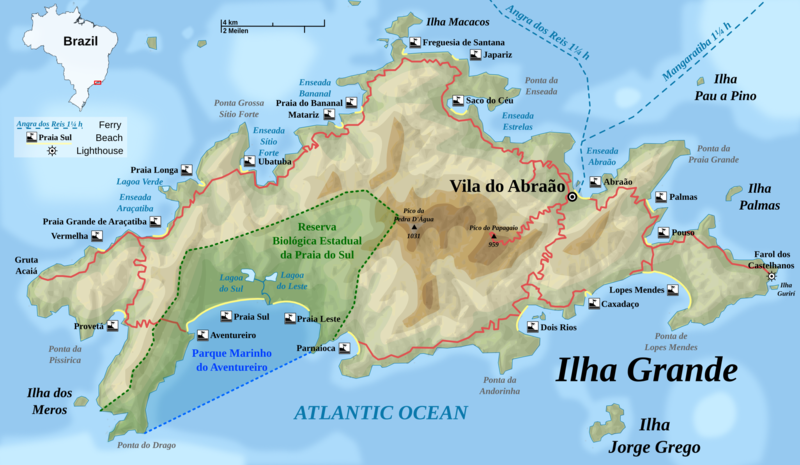
File:Ilha Grande topographic map-EN.png
外觀

預覽大小:800 × 465 像素。 其他解析度:320 × 186 像素 | 640 × 372 像素 | 1,024 × 596 像素 | 1,280 × 745 像素 | 2,052 × 1,194 像素。
原始檔案 (2,052 × 1,194 像素,檔案大小:1.52 MB,MIME 類型:image/png)
檔案歷史
點選日期/時間以檢視該時間的檔案版本。
| 日期/時間 | 縮圖 | 尺寸 | 用戶 | 備註 | |
|---|---|---|---|---|---|
| 目前 | 2009年7月5日 (日) 08:12 |  | 2,052 × 1,194(1.52 MB) | Rosso Robot | a few corrections |
| 2009年7月4日 (六) 16:30 |  | 2,052 × 1,194(1.52 MB) | Rosso Robot | {{Information |Description={{en|1=Detailed topographic map in Englisch of Ilha Grande}} {{de|1=Topografische Karte der Ilha Grande, englische Version}} Carte topographique détaillée en anglais de l'[[:fr:Ilha Gran |
檔案用途
下列頁面有用到此檔案:
全域檔案使用狀況
以下其他 wiki 使用了這個檔案:
- da.wikipedia.org 的使用狀況
- en.wikipedia.org 的使用狀況
- en.wikivoyage.org 的使用狀況
- en.wiktionary.org 的使用狀況
- es.wikipedia.org 的使用狀況
- fi.wikipedia.org 的使用狀況
- hr.wikipedia.org 的使用狀況
- hy.wikipedia.org 的使用狀況
- it.wikipedia.org 的使用狀況
- ko.wikipedia.org 的使用狀況
- lt.wikipedia.org 的使用狀況
- ru.wikipedia.org 的使用狀況
- tr.wikipedia.org 的使用狀況
- vi.wikipedia.org 的使用狀況


