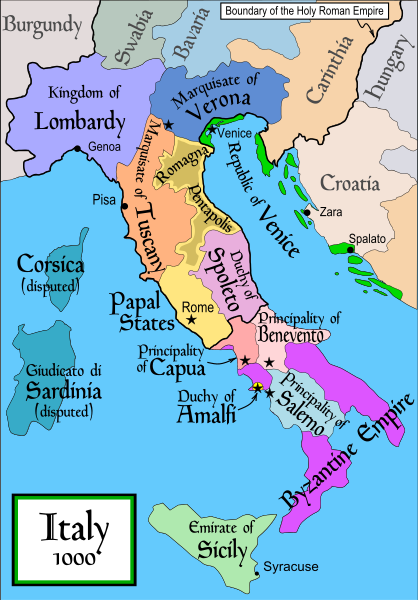
File:Italy 1000 AD.svg
外觀

此 SVG 檔案的 PNG 預覽的大小:418 × 600 像素。 其他解析度:167 × 240 像素 | 334 × 480 像素 | 535 × 768 像素 | 713 × 1,024 像素 | 1,427 × 2,048 像素 | 565 × 811 像素。
原始檔案 (SVG 檔案,表面大小:565 × 811 像素,檔案大小:861 KB)
檔案歷史
點選日期/時間以檢視該時間的檔案版本。
| 日期/時間 | 縮圖 | 尺寸 | 用戶 | 備註 | |
|---|---|---|---|---|---|
| 目前 | 2007年4月17日 (二) 19:50 |  | 565 × 811(861 KB) | MapMaster | Some further changes |
| 2007年2月19日 (一) 05:10 |  | 565 × 811(824 KB) | MapMaster | changes to ensure consistency with my other Italy maps | |
| 2006年11月25日 (六) 05:39 |  | 565 × 811(823 KB) | MapMaster | Improved map. | |
| 2006年11月18日 (六) 14:44 |  | 565 × 811(827 KB) | MapMaster | Improved (I hope) version based on recommendations from Attilios. | |
| 2006年11月17日 (五) 21:50 |  | 565 × 811(768 KB) | MapMaster | Political map of Italy in 1000 AD (CE). |
檔案用途
下列2個頁面有用到此檔案:
全域檔案使用狀況
以下其他 wiki 使用了這個檔案:
- an.wikipedia.org 的使用狀況
- ar.wikipedia.org 的使用狀況
- ast.wikipedia.org 的使用狀況
- azb.wikipedia.org 的使用狀況
- az.wikipedia.org 的使用狀況
- bg.wikipedia.org 的使用狀況
- bn.wikipedia.org 的使用狀況
- bs.wikipedia.org 的使用狀況
- ckb.wikipedia.org 的使用狀況
- cs.wikipedia.org 的使用狀況
- da.wikipedia.org 的使用狀況
- de.wikipedia.org 的使用狀況
- el.wikipedia.org 的使用狀況
- en.wikipedia.org 的使用狀況
- Lombards
- Pope Stephen IX
- Otto III, Holy Roman Emperor
- Otto II, Holy Roman Emperor
- Salerno
- Benevento
- Emirate
- Italian city-states
- List of historical states of Italy
- List of state leaders in the 10th century
- Duchy of Spoleto
- Duchy of Benevento
- Kalbids
- Rainulf Drengot
- Duchy of Amalfi
- Muslim Sicily
- Sergius IV of Naples
檢視此檔案的更多全域使用狀況。


