File:Nepkoztarsasag.png
外觀
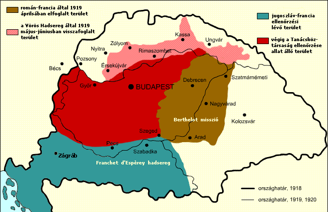
Nepkoztarsasag.png (660 × 428 像素,檔案大小:55 KB,MIME 類型:image/png)
檔案歷史
點選日期/時間以檢視該時間的檔案版本。
| 日期/時間 | 縮圖 | 尺寸 | 用戶 | 備註 | |
|---|---|---|---|---|---|
| 目前 | 2017年11月22日 (三) 13:15 |  | 660 × 428(55 KB) | Julieta39 | Diacritic corrected |
| 2017年11月22日 (三) 12:04 |  | 660 × 428(55 KB) | Julieta39 | According with "Történelmi atlasz", Kartográfiai Vállalat, Budapest 1989, ISBN 9633514223 CM | |
| 2011年2月9日 (三) 11:08 |  | 660 × 428(47 KB) | Hobartimus~commonswiki | Reverted to version as of 18:15, 6 February 2011 | |
| 2011年2月9日 (三) 00:20 |  | 660 × 428(23 KB) | Lovech~commonswiki | returning to the superior original version | |
| 2011年2月6日 (日) 18:15 |  | 660 × 428(47 KB) | 123iti | reverted unexplained edit | |
| 2011年2月5日 (六) 16:40 |  | 660 × 428(23 KB) | Lovech~commonswiki | Reverted to version as of 22:33, 28 December 2010 | |
| 2010年12月29日 (三) 00:17 |  | 660 × 428(47 KB) | 123iti | ok, then I am proposing this compromise version due to my discussion page explanation | |
| 2010年12月28日 (二) 22:33 |  | 660 × 428(23 KB) | VT | Reverted to version as of 13:20, 20 May 2009 -> this version is right, then those territories were under occupation | |
| 2010年12月6日 (一) 11:53 |  | 660 × 428(35 KB) | 123iti | There is no reason that vojvodina is colored here because it had no any relation with Hungarian Soviet Republic. See source: http://libcom.org/files/images/library/hungarianmap%5B1%5D.jpg (Transylvania, Slovakia and Transcarpathia are not colored too, so | |
| 2009年5月20日 (三) 13:20 |  | 660 × 428(23 KB) | Baxter9~commonswiki | {{Information |Description={{en|1=Military succes of the Hungarian Soviet Republic}} |Source=http://hu.wikipedia.org/wiki/F%C3%A1jl:Nepkoztarsasag.png |Author=Kovács Ádám |Date=2006 |Permission= |other_versions= }} <!--{{ImageUpload|full}}--> [[Catego |
檔案用途
下列4個頁面有用到此檔案:
全域檔案使用狀況
以下其他 wiki 使用了這個檔案:
- ar.wikipedia.org 的使用狀況
- ast.wikipedia.org 的使用狀況
- azb.wikipedia.org 的使用狀況
- az.wikipedia.org 的使用狀況
- be.wikipedia.org 的使用狀況
- bg.wikipedia.org 的使用狀況
- br.wikipedia.org 的使用狀況
- cbk-zam.wikipedia.org 的使用狀況
- cs.wikipedia.org 的使用狀況
- da.wikipedia.org 的使用狀況
- el.wikipedia.org 的使用狀況
- en.wikipedia.org 的使用狀況
- eo.wikipedia.org 的使用狀況
- et.wikipedia.org 的使用狀況
- eu.wikipedia.org 的使用狀況
- fa.wikipedia.org 的使用狀況
- fr.wikipedia.org 的使用狀況
- gl.wikipedia.org 的使用狀況
- hr.wikipedia.org 的使用狀況
- hu.wikipedia.org 的使用狀況
- hy.wikipedia.org 的使用狀況
- id.wikipedia.org 的使用狀況
- it.wikipedia.org 的使用狀況
- ja.wikipedia.org 的使用狀況
- ka.wikipedia.org 的使用狀況
- kk.wikipedia.org 的使用狀況
- ko.wikipedia.org 的使用狀況
檢視此檔案的更多全域使用狀況。


