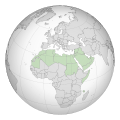
File:Arab league orthographic NED 50m.svg
頁面內容不支援其他語言。
外觀

此 SVG 檔案的 PNG 預覽的大小:550 × 550 像素。 其他解析度:240 × 240 像素 | 480 × 480 像素 | 768 × 768 像素 | 1,024 × 1,024 像素 | 2,048 × 2,048 像素。
原始檔案 (SVG 檔案,表面大小:550 × 550 像素,檔案大小:350 KB)
摘要
| 描述Arab league orthographic NED 50m.svg |
English: A map of the hemisphere showing the Arab League, centred on Libya. using an orthographic projection |
| 日期 |
2009年11月 2012年3月4日 (last version uploaded) |
| 來源 | Created using Grey-green orthographic projections maps and Gringer's Perl script with Natural Earth Data (1:50m resolution, simplified to 0.25px). |
| 作者 | User:Lexicon (with modifications by others) and Reisio at en.wikipedia / Later version(s) were uploaded by Gringer at en.wikipedia. |
| SVG開發 InfoField |
授權條款
| Public domainPublic domainfalsefalse |
| 此作品已由其作者,英文維基百科的Reisio,釋出至公有領域。此授權條款在全世界均適用。 這可能在某些國家不合法,如果是的話: Reisio授予任何人有權利使用此作品於任何用途,除受法律約束外,不受任何限制。Public domainPublic domainfalsefalse |
| Public domainPublic domainfalsefalse |
| 此作品已由其作者,英文維基百科的Gringer,釋出至公有領域。此授權條款在全世界均適用。 這可能在某些國家不合法,如果是的話: Gringer授予任何人有權利使用此作品於任何用途,除受法律約束外,不受任何限制。Public domainPublic domainfalsefalse |
原始上傳日誌
The original description page was here. All following user names refer to en.wikipedia.
- 2011-02-17 23:20 Gringer 550×550 (357596 bytes) using Natural earth data, easier to customise, recentred to Libya
- 2010-09-25 05:38 Reisio 550×550 (437253 bytes) {{Information |Description={{en|Arab_League_(orthographic_projection)}} |Source=[[Grey-green orthographic projections maps]] |Date=2009-11 |Author=[[:en:User:Lexicon|]] (with modifications by others) |Permission={{PD-self}} |other_versions= }}
العربية: الرجاء، قراءة الميثاق.
বাংলা: দয়া করে, রীতিনীতিটি পড়ুন।
Deutsch: Bitte lies die Konventionen.
English: Please, read the conventions.
Español: Por favor, lea las convenciones.
Filipino: Paki-basa ang mga kumbensyon.
Français : S'il vous plaît, lisez les conventions.
हिन्दी: कृपया सभागमों को पढ़ लें.
Bahasa Indonesia: Silakan, baca konvensi.
Italiano: Si prega di leggere le convenzioni.
日本語: 規約をご確認ください。
ქართული: გთხოვთ, გაეცნოთ კონვენციებს.
Македонски: Ве молиме, прочитајте ги општоприфатените правила.
Português: Por favor, leia as convenções.
Русский: Пожалуйста, прочитайте соглашения.
Tagalog: Paki-basa ang mga kumbensyon.
Українська: Будь ласка, прочитайте конвенції.
Tiếng Việt: Hãy đọc công văn trước khi đăng.
中文(繁體):請檢視常規
中文(简体):请查看常规
| 世界地圖 |
|---|
非洲हिन्दी: अफ्रीका
ქართული: აფრიკა.
東非हिन्दी: पूर्वी अफ्रीका
南非
中非
北非
西非
美洲ქართული: ამერიკა.
हिन्दी: अमेरिका
北美洲हिन्दी: उत्तरी अमेरिका
中美洲
加勒比
南美洲हिन्दी: दक्षिण अमेरिका
亞洲हिन्दी: एशिया (जम्भूद्वीप)
ქართული: აზია.
Português: Ásia.
Українська: Азія.
東亞हिन्दी: पूर्वी एशिया
ქართული: აღმოსავლეთი აზია.
Português: Ásia Oriental.
Українська: Східна Азія.
中亞हिन्दी: मध्य एशिया
ქართული: ცენტრალური აზია.
Português: Ásia Central.
Українська: Центральна Азія.
東南亞Filipino: Timog-silangang Asya.
हिन्दी: दक्षिण-पूर्वी एशिया
Bahasa Indonesia: Asia tenggara
ქართული: სამხრეთ-აღმოსავლეთი აზია.
Português: Sudeste Asiático.
Tagalog: Timog-silangang Asya.
Українська: Південно-Східна Азія.
南亞हिन्दी: दक्षिण एशिया (भारतीय उपमहाद्वीप)
ქართული: სამხრეთი აზია.
Português: Sul da Ásia.
Українська: Південна Азія.
西亞हिन्दी: पश्चिमी एशिया
ქართული: დასავლეთ აზია.
Português: Sudoeste da Ásia.
Українська: Передня Азія.
歐洲हिन्दी: यूरोप
ქართული: ევროპა.
Português: Europa.
Română: Europa.
Русский: Европа.
Українська: Європа.
國家
大洋洲हिन्दी: ओशिआनिया
ქართული: ოკეანეთი.
Português: Oceania.
Українська: Океанія.
大洲地圖हिन्दी: अंतर्महाद्वीपिय
ქართული: კონტინენთშორისი.
Português: Intercontinental.
Українська: Міжконтинентальні.
歷史地圖English: Unions, Organizations, Kingdoms, Empires
Español: Uniones, Organizaciones, Reinos, Imperios
Filipino: Mga Unyon, Organisasyon, Kaharian, Imperyo
Français : Unions, Organisations, Royaumes, Empires
हिन्दी: संघ, संगठन, राज्य, साम्राज्य व ऐतिहासिक देश
ქართული: გაერთიანებები, ორგანიზაციები, სამეფოები, იმპერიები
Português: Estados extintos.
Tagalog: Mga Unyon, Organisasyon, Kaharian, Imperyo
Українська: Союзи, Організації, Королівства, Імперії
中文(繁體):聯盟、組織、王國和帝國
中文(简体):联盟、组织、王国和帝国
地方地圖हिन्दी: उपराष्ट्रीय इकाईयाँ
ქართული: სუბეროვნული ერთეულები.
Português: Entidades subnacionais.
Українська: Субнаціональні утворення.
|
說明
添加單行說明來描述出檔案所代表的內容
在此檔案描寫的項目
描繪內容
著作權狀態 繁體中文 (已轉換拼寫)
保有知識產權並由其所有者公開於公有領域 繁體中文 (已轉換拼寫)
著作權持有者釋出至公有領域 繁體中文 (已轉換拼寫)
多媒體型式 繁體中文 (已轉換拼寫)
image/svg+xml
資料大小 Chinese (Hong Kong) (已轉換拼寫)
357,952 位元組
550 像素
550 像素
檔案歷史
點選日期/時間以檢視該時間的檔案版本。
| 日期/時間 | 縮圖 | 尺寸 | 用戶 | 備註 | |
|---|---|---|---|---|---|
| 目前 | 2012年3月4日 (日) 19:52 |  | 550 × 550(350 KB) | Domaina | Without South Sudan |
| 2011年4月26日 (二) 05:19 |  | 550 × 550(349 KB) | OgreBot | (BOT): Reverting to the most recent version before uploads (originally uploaded on 2011-02-17 23:20 by Gringer). | |
| 2011年4月26日 (二) 05:19 |  | 550 × 550(427 KB) | OgreBot | (BOT): This is the version originally uploaded on 2010-09-25 05:38 by Reisio; storing on commons for archival purposes | |
| 2011年2月17日 (四) 23:24 |  | 550 × 550(349 KB) | Gringer | {{Information |Description ={{en|1=A map of the hemisphere showing the Arab League, centred on Libya, using an orthographic projection and created using gringer's Perl script with [http://www.naturalearthd |
檔案用途
沒有使用此檔案的頁面。
全域檔案使用狀況
以下其他 wiki 使用了這個檔案:
- bg.wikipedia.org 的使用狀況
- fr.wikipedia.org 的使用狀況
隱藏分類:


