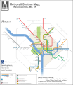
File:DC Metro Map 2013.svg
外觀

此 SVG 檔案的 PNG 預覽的大小:566 × 599 像素。 其他解析度:227 × 240 像素 | 453 × 480 像素 | 726 × 768 像素 | 967 × 1,024 像素 | 1,935 × 2,048 像素 | 1,539 × 1,629 像素。
原始檔案 (SVG 檔案,表面大小:1,539 × 1,629 像素,檔案大小:4.48 MB)
檔案歷史
點選日期/時間以檢視該時間的檔案版本。
| 日期/時間 | 縮圖 | 尺寸 | 用戶 | 備註 | |
|---|---|---|---|---|---|
| 目前 | 2015年12月3日 (四) 17:31 |  | 1,539 × 1,629(4.48 MB) | Pi.1415926535 | Reduce height |
| 2015年12月3日 (四) 17:27 |  | 1,539 × 1,779(4.47 MB) | Pi.1415926535 | Fixed misaligned background | |
| 2015年12月2日 (三) 22:11 |  | 1,539 × 1,779(4.47 MB) | Pi.1415926535 | Update station names | |
| 2015年12月2日 (三) 21:24 |  | 1,539 × 1,779(4.48 MB) | Pi.1415926535 | Increase width for better visibility (no other changes) | |
| 2014年8月19日 (二) 09:23 |  | 512 × 592(4.09 MB) | Rcsprinter123 | Cemetery, Mongomery | |
| 2013年10月18日 (五) 02:06 |  | 512 × 592(3.98 MB) | VeggieGarden | Added parking at Wiehle-Reston East Station, fixed "accessible" spelling error | |
| 2013年10月16日 (三) 23:56 |  | 512 × 592(3.86 MB) | VeggieGarden | Fixed More Errors, made the map more readable | |
| 2013年10月16日 (三) 23:56 |  | 512 × 592(3.86 MB) | VeggieGarden | Fixed More Errors, made the map more readable | |
| 2013年10月16日 (三) 23:43 |  | 512 × 592(586 KB) | VeggieGarden | Fixed errors | |
| 2013年10月16日 (三) 23:35 |  | 512 × 592(284 KB) | VeggieGarden | Brand New design, more accurate, addition of Silver Line Phase 1. The map is also easier to understand. |
檔案用途
下列頁面有用到此檔案:
全域檔案使用狀況
以下其他 wiki 使用了這個檔案:
- en.wikipedia.org 的使用狀況
- pt.wikipedia.org 的使用狀況


