跳至內容

File:Pia16128-640-MatijevicHill-EnduranceCrater-20120928.jpg

頁面內容不支援其他語言。
這個檔案來自維基共享資源
維基百科,自由的百科全書

Pia16128-640-MatijevicHill-EnduranceCrater-20120928.jpg (640 × 350 像素,檔案大小:217 KB,MIME 類型:image/jpeg


摘要

描述
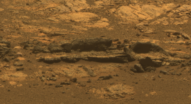
English: Opportunity Eyes Rock Fins on Cape York, Sol 3058

Rock fins up to about 1 foot (30 centimeters) tall dominate this scene from the panoramic camera (Pancam) on NASA's Mars Exploration Rover Opportunity. The component images were taken during the 3,058th Martian day, or sol, of Opportunity's work on Mars (Aug. 23, 2012). The view spans an area of terrain about 30 feet (9 meters) wide. This outcrop is within an area informally named "Matijevic Hill."

Orbital investigation of the area has identified a possibility of clay minerals in this area of the Cape York segment of the western rim of Endeavour Crater.

The view combines exposures taken through Pancam filters centered on wavelengths of 753 nanometers (near infrared), 535 nanometers (green) and 432 nanometers (violet). It is presented in approximate true color, the camera team's best estimate of what the scene would look like if humans were there and able to see it with their own eyes.

Image credit: NASA/JPL-Caltech/Cornell Univ./Arizona State Univ.
日期
來源 http://www.jpl.nasa.gov/news/news.php?release=2012-306
作者 NASA/JPL-Caltech/Cornell Univ./Arizona State Univ.
其他版本 http://www.nasa.gov/mission_pages/mer/multimedia/pia16128.html

授權條款

Public domain 本作品由NASA創作,屬於公有領域。根據NASA的版權政策:“NASA的創作除非另有聲明否則不受版權保護。”(參見:Template:PD-USGov/zhNASA版權政策JPL圖像使用政策
警告:

說明

添加單行說明來描述出檔案所代表的內容

在此檔案描寫的項目

描繪內容

著作權狀態 繁體中文 (已轉換拼寫)

斷定方法:​美國聯邦政府的作品 繁體中文 (已轉換拼寫)

檔案歷史

點選日期/時間以檢視該時間的檔案版本。

日期/時間縮⁠圖尺寸用戶備⁠註
目前2012年10月13日 (六) 13:47於 2012年10月13日 (六) 13:47 版本的縮圖640 × 350(217 KB)DrbogdanUser created page with UploadWizard

下列頁面有用到此檔案:

全域檔案使用狀況

以下其他 wiki 使用了這個檔案:

詮釋資料