跳至內容

File:The Earth and the Moon photographed from Mars orbit.jpg

頁面內容不支援其他語言。
這個檔案來自維基共享資源
維基百科,自由的百科全書

原始檔案 (800 × 800 像素,檔案大小:9 KB,MIME 類型:image/jpeg


摘要

描述
English: Original caption:

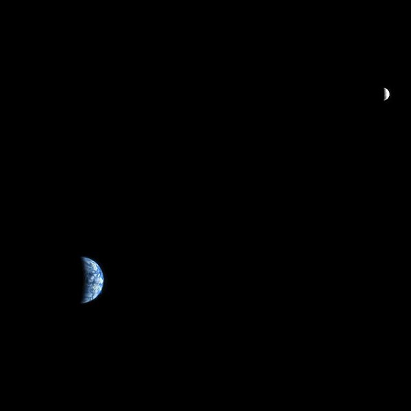
The High Resolution Imaging Science Experiment (HiRISE) camera would make a great backyard telescope for viewing Mars, and we can also use it at Mars to view other planets. This is an image of Earth and the moon, acquired on October 3, 2007, by the HiRISE camera on NASA's Mars Reconnaissance Orbiter.

At the time the image was taken, Earth was 142 million kilometers (88 million miles) from Mars, giving the HiRISE image a scale of 142 kilometers (88 miles) per pixel, an Earth diameter of about 90 pixels and a moon diameter of 24 pixels. The phase angle is 98 degrees, which means that less than half of the disk of the Earth and the disk of the moon have direct illumination. We could image Earth and moon at full disk illumination only when they are on the opposite side of the sun from Mars, but then the range would be much greater and the image would show less detail.

On the day this image was taken, the Japanese Kaguya (Selene) spacecraft was en route from the Earth to the moon, and has since returned spectacular images and movies (see http://www.jaxa.jp/projects/sat/selene/index_e.html).

On the Earth image we can make out the west coast outline of South America at lower right, although the clouds are the dominant features. These clouds are so bright, compared with the moon, that they are saturated in the HiRISE images. In fact the red-filter image was almost completely saturated, the Blue-Green image had significant saturation, and the brightest clouds were saturated in the infrared image. This color image required a fair amount of processing to make a nice-looking release. The moon image is unsaturated but brightened relative to Earth for this composite. The lunar images are useful for calibration of the camera.

Polski: Ziemia i Księżyc widziane z Marsa

Marsjańska orbitalna kamera ang. High Resolution Imaging Science Experiment (HiRISE), będąca wspaniałym teleskopem do oglądania powierzchni Marsa, może być także użyta do oglądania innych planet. Obraz Ziemi i Księżyca, został wykonany w dniu 3 października 2007 roku, przez kamerę HiRISE, znajdującą się na pokładzie należącego do NASA orbitera Mars Reconnaissance Orbiter.

W czasie kiedy to zdjęcie zostało wykonane, Ziemia była oddalona 142.000.000 km od Marsa, dając obraz HiRISE o skali 142 km na piksel, co dla średnicy Ziemi oznaczoło około 90 pikseli i dla średnicy Księżyca 24 pikseli. Kąt fazowy wynosi 98 stopni, co oznacza, że mniej niż połowa tarczy Ziemi i dysku księżyca mają bezpośrednie oświetlenie słoneczne. Wykonanie zdjęcia Ziemi i Księżyca w pełnej iluminacji jest możliwe tylko wtedy, gdy są one na przeciwnej stronie Słońca niż Mars, ale wtedy odległość do nich byłaby znacznie większa, a obraz pokazywałby mniej szczegółów.

W dniu, w którym zdjęcie to zostało zrobione, japoński statek kosmiczny Kaguya (Selene) był w drodze z Ziemi na Księżyc, a później przesłał spektakularne zdjęcia i filmy (patrz http://www.jaxa.jp/projects/sat/selene/index_e.html).

Chociaż dominującym elementem są chmury, w prawym dolnym rogu obrazu Ziemi, możemy rozpoznać kontur zachodniego wybrzeża Ameryki Południowej. Chmury są tak jasne, w porównaniu z Księżycem, ponieważ są nasycone w obrazach HiRISE. W rzeczywistości czerwony filtr został prawie całkowicie nasycony, niebiesko-zielony był nasycony w stopniu znaczącym, a najjaśniejsze chmury były nasycone w podczerwieni. Ten kolorowy obraz wymagał rzetelnego przetworzenia, aby uzyskać oczekiwany efekt. Obraz Księżyca jest nienasycony, ale rozjaśniony względem Ziemi. Zdjęcia Księżyca są przydatne do kalibracji kamery.

Image Credit: NASA/JPL-Caltech/University of Arizona

來源 http://www.nasa.gov/mission_pages/MRO/multimedia/mro20080303earth.html
作者 NASA/JPL-Caltech/University of Arizona

授權條款

Public domain 本作品由NASA創作,屬於公有領域。根據NASA的版權政策:“NASA的創作除非另有聲明否則不受版權保護。”(參見:Template:PD-USGov/zhNASA版權政策JPL圖像使用政策
警告:

This is one of the images forming part of the Valued image set: Earth from space on Wikimedia Commons. The image set has been assessed under the valued image set criteria and is considered the most valued set on Commons within the scope:

You can see its nomination at Commons:Valued image candidates/Earth from space.

說明

添加單行說明來描述出檔案所代表的內容

在此檔案描寫的項目

描繪內容

著作權狀態 繁體中文 (已轉換拼寫)

斷定方法:​美國聯邦政府的作品 繁體中文 (已轉換拼寫)

資料大小 Chinese (Hong Kong) (已轉換拼寫)

8,741 位元組

800 像素

800 像素

多媒體型式 繁體中文 (已轉換拼寫)

image/jpeg

校驗和 繁體中文 (已轉換拼寫)

0e6c52d460cd304527908245f7b78bd815aa5993

斷定方法:​SHA-1 中文 (已轉換拼寫)

檔案歷史

點選日期/時間以檢視該時間的檔案版本。

日期/時間縮⁠圖尺寸用戶備⁠註
目前2008年4月12日 (六) 19:43於 2008年4月12日 (六) 19:43 版本的縮圖800 × 800(9 KB)Njardarlogar{{Information |Description= Original caption: The High Resolution Imaging Science Experiment (HiRISE) camera would make a great backyard telescope for viewing Mars, and we can also use it at Mars to view other planets. This is an image of Earth and the mo

下列2個頁面有用到此檔案:

全域檔案使用狀況

以下其他 wiki 使用了這個檔案:

詮釋資料