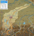
File:Verlaufskarte Isar (de).png
外觀

預覽大小:573 × 599 像素。 其他解析度:229 × 240 像素 | 459 × 480 像素 | 734 × 768 像素 | 979 × 1,024 像素 | 1,709 × 1,788 像素。
原始檔案 (1,709 × 1,788 像素,檔案大小:4.43 MB,MIME 類型:image/png)
檔案歷史
點選日期/時間以檢視該時間的檔案版本。
| 日期/時間 | 縮圖 | 尺寸 | 用戶 | 備註 | |
|---|---|---|---|---|---|
| 目前 | 2011年12月19日 (一) 13:49 |  | 1,709 × 1,788(4.43 MB) | TomGonzales | +schrift nochmals grösser, und diverses gefixt |
| 2011年12月18日 (日) 23:58 |  | 1,709 × 1,788(4.43 MB) | TomGonzales | Diverse Verbesserungen, Tippfehler entfernt, +Walchenseekraftwerk, +Achenseekraftwerk | |
| 2011年12月17日 (六) 18:54 |  | 1,709 × 1,788(4.27 MB) | TomGonzales | == {{int:filedesc}} == {{Information |Description= {{de|Verlaufskarte der Isar.}} {{en|Map of the River Isar in South Germany.}} |Source= *[http://www.openstreetmap.org/?lat=49.45&lon=18.29&zoom=6&layers=M Open Street Map] *Reliefkarte generiert mit Hilf |
檔案用途
沒有使用此檔案的頁面。
全域檔案使用狀況
以下其他 wiki 使用了這個檔案:
- cs.wikipedia.org 的使用狀況
- de.wikipedia.org 的使用狀況
- frr.wikipedia.org 的使用狀況
- he.wikipedia.org 的使用狀況
- hu.wikipedia.org 的使用狀況
- it.wikipedia.org 的使用狀況
- lld.wikipedia.org 的使用狀況
- pl.wikipedia.org 的使用狀況
- pnb.wikipedia.org 的使用狀況
- vls.wikipedia.org 的使用狀況
- www.wikidata.org 的使用狀況


