跳转到内容

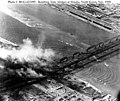
File:Bombing of Yalu River Bridges at Sinuiju - Dandong Nov.1950.jpg

页面内容不支持其他语言。
这个文件来自维基共享资源
维基百科,自由的百科全书

原始文件 (740 × 620像素,文件大小:140 KB,MIME类型:image/jpeg


摘要

描述
English: Arial photograph of bomb damage during United States air attacks on the Yalu River Bridges between Sinuiju in North Korea and Dandong in China. The photograph is dated 18th November, 1950 though the source suggests that 14th of November is a probable date.
日期
来源 Photo #: 80-G-423495, Attacks on Yalu River Bridges, November 1950. Official U.S. Navy Photograph, now in the collections of the National Archives. Sourced from web page at http://www.history.navy.mil/photos/events/kowar/50-unof/un-2a.htm
作者 U.S. Navy
相机位置40° 06′ 54″ 北, 124° 23′ 34″ 东 Kartographer map based on OpenStreetMap.在以下服务上查看本图像和附近其他图像: OpenStreetMapinfo

许可协议

Public domain
本图片或文件是由美国空军的军人或雇员,基于其个人公务目的拍摄或制作的作品。作为美国联邦政府作品,本图片或文件在美国属于公有领域

العربية  беларуская (тарашкевіца)  català  čeština  Deutsch  English  español  eesti  فارسی  suomi  français  italiano  日本語  한국어  македонски  മലയാളം  မြန်မာဘာသာ  norsk bokmål  Plattdüütsch  Nederlands  polski  português  português do Brasil  русский  sicilianu  slovenčina  slovenščina  српски / srpski  svenska  Türkçe  українська  Tiếng Việt  中文(简体)  中文(繁體)  +/−

说明

添加一行文字以描述该文件所表现的内容

此文件中描述的项目

描绘内容

版权状态 简体中文(已转写)

视角坐标 简体中文(已转写)

40°6'54.000"N, 124°23'34.001"E

媒体类型 简体中文(已转写)

image/jpeg

校验和 简体中文(已转写)

aaefb0573bce7e3b47d4bdda86c9fa3b31dc7f26

断定方法:​SHA-1 简体中文(已转写)

数据大小 简体中文(已转写)

143,184 字节

620 像素

740 像素

文件历史

点击某个日期/时间查看对应时刻的文件。

日期/时间缩⁠略⁠图大小用户备注
当前2009年10月5日 (一) 03:312009年10月5日 (一) 03:31版本的缩略图740 × 620(140 KB)Rincewind42{{Information |Description={{en|1=Arial photograph of bomb damage during United States air attacs on the Yulu River Bridges between Sinuiju in North Korea and Dandong in China. The photograph is dated 18th November, 1950 though the source suggests that 14

以下2个页面使用本文件:

全域文件用途

以下其他wiki使用此文件:

元数据