跳转到内容

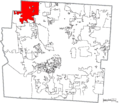
File:Map of Franklin County Ohio Highlighting Dublin City.png

页面内容不支持其他语言。
这个文件来自维基共享资源
维基百科,自由的百科全书

原始文件 (1,174 × 1,003像素,文件大小:111 KB,MIME类型:image/png


描述
English: Map of the municipal and township boundaries of Franklin County, Ohio, United States, as of the 2000 census, with the location of the city of Dublin highlighted. Township borders are shown only in unincorporated areas in order to differentiate incorporated and unincorporated areas more clearly. Due to the extremely fractured nature of the county's municipal boundaries, details of boundaries and the identity of township islands may be inaccurate.
日期
来源 File:Map of Franklin County Ohio With Municipal and Township Labels.PNG
作者 Ruhrfisch and Nyttend
授权
(二次使用本文件)
w:zh:知识共享
署名 相同方式共享
您可以自由地:
  • 共享 – 复制、发行并传播本作品
  • 修改 – 改编作品
惟须遵守下列条件:
  • 署名 – 您必须对作品进行署名,提供授权条款的链接,并说明是否对原始内容进行了更改。您可以用任何合理的方式来署名,但不得以任何方式表明许可人认可您或您的使用。
  • 相同方式共享 – 如果您再混合、转换或者基于本作品进行创作,您必须以与原先许可协议相同或相兼容的许可协议分发您贡献的作品。

说明

添加一行文字以描述该文件所表现的内容

此文件中描述的项目

描绘内容

版权状态 简体中文(已转写)

版权所有 简体中文(已转写)

文件历史

点击某个日期/时间查看对应时刻的文件。

日期/时间缩⁠略⁠图大小用户备注
当前2015年8月23日 (日) 14:392015年8月23日 (日) 14:39版本的缩略图1,174 × 1,003(111 KB)Nyttend{{Information |Description={{en|Map of the municipal and township boundaries of {{w|Franklin County, Ohio|Franklin County}}, {{w|Ohio}}, {{w|United States}}, as of the 2000 census, with the location of the city of {{w|Dublin, Ohio|Dublin}} highlighted....

以下页面使用本文件:

全域文件用途

以下其他wiki使用此文件:

元数据