File:Be-map-fr.png
外观
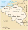
Be-map-fr.png (330 × 355像素,文件大小:27 KB,MIME类型:image/png)
文件历史
点击某个日期/时间查看对应时刻的文件。
| 日期/时间 | 缩略图 | 大小 | 用户 | 备注 | |
|---|---|---|---|---|---|
| 当前 | 2020年4月13日 (一) 21:08 |  | 330 × 355(27 KB) | Le Fou | Zeebrugge is not a city, but part of the city of Bruges. |
| 2006年1月5日 (四) 16:37 |  | 330 × 355(28 KB) | Jrenier | A map of Belgium, converted directly from a map in GIF format from the CIA World Factbook. '''French version !''' Version francaise de la carte de Belgique. {{PD-USGov-CIA-WF}} |
文件用途
以下页面使用本文件:
全域文件用途
以下其他wiki使用此文件:
- de.wikipedia.org上的用途
- de.wikinews.org上的用途
- fr.wikipedia.org上的用途
- fr.wikinews.org上的用途
- ln.wikipedia.org上的用途
- nrm.wikipedia.org上的用途
- oc.wikipedia.org上的用途
- pcd.wikipedia.org上的用途
- wa.wikipedia.org上的用途
- wo.wikipedia.org上的用途


