
File:CrozetMapEst.png
此為最大尺寸。
CrozetMapEst.png (390 × 274 像素,檔案大小:39 KB,MIME 類型:image/png)
摘要
| 描述 |
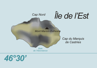
Deutsch: Karte der Île de l’Est, Crozetinseln, im südlichen Indischen Ozean
English: Map of Île de l’Est, Crozet Islands, in the Southern Indian Ocean |
| 日期 | |
| 來源 | 自己的作品, based on original from Varp |
| 作者 | modified by Telim tor |
| 其他版本 |

授權條款
| |
此作品已由其作者,[[:commons:|中文維基百科]]專案的Varp,釋出至公有領域。此授權條款在全世界均適用。 如果法律不適用時: |
檔案歷史
點選日期/時間以檢視該時間的檔案版本。
| 日期/時間 | 縮圖 | 尺寸 | 使用者 | 備註 | |
|---|---|---|---|---|---|
| 目前 | 2009年6月3日 (三) 12:05 | | 390 × 274(39 KB) | Telim tor | correct latitude |
| 2009年6月3日 (三) 11:57 |  | 390 × 274(38 KB) | Telim tor | == {{int:filedesc}} == {{Information |Description= {{de|Karte der Île de l’Est, Crozetinseln, im südlichen Indischen Ozean}} {{en|Map of Île de l’Est, Crozet Islands, in the Southern Indian Ocean}} |Source={{own}}, based on original from [[User:Var |
檔案用途
下列頁面有用到此檔案:
全域檔案使用狀況
以下其他 wiki 使用了這個檔案:
- af.wikipedia.org 的使用狀況
- ceb.wikipedia.org 的使用狀況
- de.wikipedia.org 的使用狀況
- en.wikipedia.org 的使用狀況
- en.wikivoyage.org 的使用狀況
- fr.wikipedia.org 的使用狀況
- hr.wikipedia.org 的使用狀況
- id.wikipedia.org 的使用狀況
- it.wikipedia.org 的使用狀況
- lld.wikipedia.org 的使用狀況
- mk.wikipedia.org 的使用狀況
- nn.wikipedia.org 的使用狀況
- pt.wikipedia.org 的使用狀況
- www.wikidata.org 的使用狀況