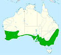
File:Distribution red wattlebird.jpg
外觀

預覽大小:667 × 599 像素。 其他解析度:267 × 240 像素 | 534 × 480 像素 | 855 × 768 像素 | 1,140 × 1,024 像素 | 2,056 × 1,847 像素。
原始檔案 (2,056 × 1,847 像素,檔案大小:325 KB,MIME 類型:image/jpeg)
檔案歷史
點選日期/時間以檢視該時間的檔案版本。
| 日期/時間 | 縮圖 | 尺寸 | 使用者 | 備註 | |
|---|---|---|---|---|---|
| 目前 | 2016年2月7日 (日) 10:48 |  | 2,056 × 1,847(325 KB) | Aa77zz | Expand range in arid area of southern WA south of Laverton based on Birddata. The low density of reported sightings makes it difficult to know where to draw the line. Also move boundary north of Murray River, the Victoria NSW boundary. Note that there... |
| 2016年2月6日 (六) 21:47 |  | 2,056 × 1,847(326 KB) | Aa77zz | Improved colouring | |
| 2016年2月6日 (六) 18:09 |  | 2,056 × 1,847(334 KB) | Aa77zz | User created page with UploadWizard |
檔案用途
下列頁面有用到此檔案:
全域檔案使用狀況
以下其他 wiki 使用了這個檔案:
- ar.wikipedia.org 的使用狀況
- arz.wikipedia.org 的使用狀況
- ast.wikipedia.org 的使用狀況
- bg.wikipedia.org 的使用狀況
- br.wikipedia.org 的使用狀況
- ca.wikipedia.org 的使用狀況
- ceb.wikipedia.org 的使用狀況
- cy.wikipedia.org 的使用狀況
- en.wikipedia.org 的使用狀況
- eu.wikipedia.org 的使用狀況
- hu.wikipedia.org 的使用狀況
- nl.wikipedia.org 的使用狀況
- nv.wikipedia.org 的使用狀況
- pl.wikipedia.org 的使用狀況
- sv.wikipedia.org 的使用狀況
- tr.wikipedia.org 的使用狀況
- uk.wikipedia.org 的使用狀況
- www.wikidata.org 的使用狀況

