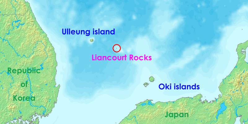
File:Location-of-Liancourt-rocks-en.png
外觀

預覽大小:800 × 400 像素。 其他解析度:320 × 160 像素 | 938 × 469 像素。
原始檔案 (938 × 469 像素,檔案大小:286 KB,MIME 類型:image/png)
檔案歷史
點選日期/時間以檢視該時間的檔案版本。
| 日期/時間 | 縮圖 | 尺寸 | 使用者 | 備註 | |
|---|---|---|---|---|---|
| 目前 | 2008年7月17日 (四) 05:36 |  | 938 × 469(286 KB) | Ponta2 | Reverted to version as of 19:08, 6 April 2008 |
| 2008年7月16日 (三) 12:03 |  | 800 × 400(332 KB) | 쿠도군 | ||
| 2008年4月6日 (日) 19:08 |  | 938 × 469(286 KB) | Eurodollers | == Summary == {{Information |Description={{en|Location of Liancourt Rocks, where Korea and Japan claim that Liancourt rocks is their own territory.}} |Source= http://www.demis.nl/wms/mapclip.htm |Date= 12 May 2006 (original upload date) |Author= demis.nl | |
| 2007年6月5日 (二) 01:41 |  | 640 × 320(57 KB) | Tene~commonswiki | Optimised (0;r) | |
| 2006年10月18日 (三) 09:43 |  | 640 × 320(60 KB) | Conscious | Reverted to earlier revision | |
| 2006年5月12日 (五) 14:00 |  | 640 × 320(60 KB) | LERK | Location of Liancourt Rocks, where Korea and Japan claim that Liancourt rocks is their own territoriy. {{demis-pd}} Category:Maps of disputed territories Category:Maps of Korea Category:Islands of Korea Category:Maps of Japan [[Category:Is |
檔案用途
沒有使用此檔案的頁面。
全域檔案使用狀況
以下其他 wiki 使用了這個檔案:
- af.wikipedia.org 的使用狀況
- ar.wikipedia.org 的使用狀況
- bat-smg.wikipedia.org 的使用狀況
- bh.wikipedia.org 的使用狀況
- ca.wikipedia.org 的使用狀況
- de.wikipedia.org 的使用狀況
- en.wikipedia.org 的使用狀況
- eo.wikipedia.org 的使用狀況
- es.wikipedia.org 的使用狀況
- fa.wikipedia.org 的使用狀況
- fi.wikipedia.org 的使用狀況
- fr.wikipedia.org 的使用狀況
- he.wikipedia.org 的使用狀況
- hi.wikipedia.org 的使用狀況
- id.wikipedia.org 的使用狀況
- it.wikipedia.org 的使用狀況
- ja.wikibooks.org 的使用狀況
- lt.wikipedia.org 的使用狀況
- ms.wikipedia.org 的使用狀況
- nl.wikipedia.org 的使用狀況
- no.wikipedia.org 的使用狀況
- pa.wikipedia.org 的使用狀況
- pl.wikipedia.org 的使用狀況
- pt.wikipedia.org 的使用狀況
- ro.wikipedia.org 的使用狀況
- simple.wikipedia.org 的使用狀況
檢視此檔案的更多全域使用狀況。


