跳至內容

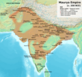
File:Maurya Empire, c.250 BCE.png

頁面內容不支援其他語言。
這個檔案來自維基共享資源
維基百科,自由的百科全書

原始檔案 (1,200 × 1,121 像素,檔案大小:2.3 MB,MIME 類型:image/png


摘要

描述

This is based on the map provided on p. 69 of Kulke, H.; Rothermund, D. (2004), A History of India, 4th, Routledge, ISBN 978-0-415-32920-0.

  • According to the authors, the empty areas within the boundaries of the empire were the "autonomous and free tribes".
  • For individual edicts, see also: Schwartzberg, J. E. (1992), A Historical Atlas of South Asia: University of Oxford Press; and https://en.wikipedia.org/wiki/List_of_Edicts_of_Ashoka
  • According to both Kulke & Rothermund (p. 68-71), as well as Stein (p. 74), large areas, especially in the Deccan peninsula, were probably occupied by fairly autonomous or even unconquered tribes.

    "Of course, it is not impossible that some may be still discovered but after more than a century of intensive research in this field it seems highly unlikely that the regional pattern mentioned above would have to be completely revised. This means that large parts of present Maharashtra and Andhra Pradesh as well as Kerala and Tamil Nadu were not actually included in the Maurya empire. South of the Vindhya mountains the Mauryas mainly controlled the coastal areas and some of the interior near present Mysore which they probably coveted because of the gold which was found there (Suvarnagiri means ‘gold mountain’). For the empire it was essential to control the major trade routes. Most important was certainly the northern route which led from Pataliputra through the Gangetic plain and the Panjab to Afghanistan. Another led from Pataliputra west via Kausambi and then along the northern slope of the Vindhya mountains via Vidisha (Sanchi) and Ujjain to the port of Bharukacha (Broach). There was a further route from there along the west coast to the area of present Bombay where the great rock edicts of Sopara were found. Southern parts could be reached along the east coast or via a central route from Ujjain via Pratishthana (Paithan near Aurangabad) to Suvarnagiri."

  • "The major part of the Deccan was ruled by [Mauryan administration]. But in the belt of land on either side of the Nerbudda, the Godavari and the upper Mahanadi there were, in all probability, certain areas that were technically outside the limits of the empire proper. Asoka evidently draws a distinction between the forests and the inhabiting tribes which are in the dominions (vijita) and peoples on the border (anta avijita) for whose benefit some of the special edicts were issued. Certain vassal tribes are specifically mentioned." (Raychaudhuri & Mukherjee pp. 275-6)
  • "Desert of Gedrosia [...] was left an unclaimed wilderness." —Kosmin, Paul J. (2014), The Land of the Elephant Kings Space, Territory, and Ideology in the Seleucid Empire, Harvard University Press, p.16
  • See also --Stein, Burton (1998). A History of India (1st ed.), Oxford: Wiley-Blackwell. --Raychaudhuri, H. C.; Mukherjee, B. N. (1996). Political History of Ancient India: From the Accession of Parikshit to the Extinction of the Gupta Dynasty. Oxford University Press.
  • Background from http://www2.demis.nl/mapserver/mapper.asp
  • Made with GIMP
日期
來源 自己的作品
作者 Avantiputra7

授權條款

我,本作品的著作權持有者,決定用以下授權條款發佈本作品:
w:zh:創用CC
姓名標示 相同方式分享
您可以自由:
  • 分享 – 複製、發佈和傳播本作品
  • 重新修改 – 創作演繹作品
惟需遵照下列條件:
  • 姓名標示 – 您必須指名出正確的製作者,和提供授權條款的連結,以及表示是否有對內容上做出變更。您可以用任何合理的方式來行動,但不得以任何方式表明授權條款是對您許可或是由您所使用。
  • 相同方式分享 – 若要根據本素材進行再混合、轉換或創作,則必須以與原作相同或相容的授權來發布您的作品。

說明

添加單行說明來描述出檔案所代表的內容
India under Maurya rule c. 250 BCE

在此檔案描寫的項目

描繪內容

2,414,939 位元組

1,121 像素

1,200 像素

747739b8cac1da12231d96841e9fc3c1bf9ab3fd

斷定方法:​SHA-1 中文 (已轉換拼寫)

檔案歷史

點選日期/時間以檢視該時間的檔案版本。

最新 | 最早) 檢視(較新 10 筆 | )(10 | 20 | 50 | 100 | 250 | 500
日期/時間縮⁠圖尺寸使用者備⁠註
目前2024年1月29日 (一) 02:15於 2024年1月29日 (一) 02:15 版本的縮圖1,200 × 1,121(2.3 MB)Avantiputra7as per discussions added labelling of provinces
2023年11月22日 (三) 06:40於 2023年11月22日 (三) 06:40 版本的縮圖1,200 × 1,121(2.06 MB)Avantiputra7Reverted to version as of 05:59, 22 November 2023 (UTC) no justification for changing to less legible version of exactly the same map
2023年11月22日 (三) 06:14於 2023年11月22日 (三) 06:14 版本的縮圖1,500 × 1,309(2.93 MB)Indo12122Reverted to version as of 05:34, 22 November 2023 (UTC) Stop hijacking.
2023年11月22日 (三) 05:59於 2023年11月22日 (三) 05:59 版本的縮圖1,200 × 1,121(2.06 MB)Avantiputra7Reverted to version as of 05:06, 22 November 2023 (UTC)
2023年11月22日 (三) 05:34於 2023年11月22日 (三) 05:34 版本的縮圖1,500 × 1,309(2.93 MB)Indo12122Reverted to version as of 19:00, 21 November 2023 (UTC)
2023年11月22日 (三) 05:06於 2023年11月22日 (三) 05:06 版本的縮圖1,200 × 1,121(2.06 MB)Avantiputra7Reverted to version as of 18:13, 21 November 2023 (UTC) rv vandalism
2023年11月21日 (二) 19:00於 2023年11月21日 (二) 19:00 版本的縮圖1,500 × 1,309(2.93 MB)Indo12122Reverted to version as of 17:53, 21 November 2023 (UTC) Adding Gedrosia .Ray, Himanshu Prabha (2003). The Archaeology of Seafaring in Ancient South Asia. Cambridge University Press. ISBN 978-0-521-01109-9. In spite of the vagueness of the historical texts, the consensus among scholars is that the treaty concluded between Candragupta Maurya and Seleucus acknowledged Indian control of territories to the west of the Indus. These included Gedrosia, Paropamisadae (the region of Kabul and Begram) a...
2023年11月21日 (二) 18:13於 2023年11月21日 (二) 18:13 版本的縮圖1,200 × 1,121(2.06 MB)Avantiputra7Reverted to version as of 17:07, 21 November 2023 (UTC) no justification for changing to less legible version of exactly the same map
2023年11月21日 (二) 17:53於 2023年11月21日 (二) 17:53 版本的縮圖1,500 × 1,309(2.93 MB)Indo12122Reverted to version as of 16:58, 21 November 2023 (UTC)
2023年11月21日 (二) 17:07於 2023年11月21日 (二) 17:07 版本的縮圖1,200 × 1,121(2.06 MB)Avantiputra7Reverted to version as of 16:36, 21 November 2023 (UTC)
最新 | 最早) 檢視(較新 10 筆 | )(10 | 20 | 50 | 100 | 250 | 500

下列頁面有用到此檔案:

全域檔案使用狀況

以下其他 wiki 使用了這個檔案:

詮釋資料