File:Mapmaunaloa.png
外观
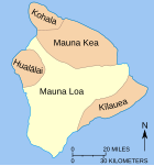
Mapmaunaloa.png (279 × 299像素,文件大小:4 KB,MIME类型:image/png)
文件历史
点击某个日期/时间查看对应时刻的文件。
| 日期/时间 | 缩略图 | 大小 | 用户 | 备注 | |
|---|---|---|---|---|---|
| 当前 | 2010年6月24日 (四) 12:52 |  | 279 × 299(4 KB) | Ras67 | cropped and squeezed |
| 2009年7月13日 (一) 06:34 |  | 281 × 301(8 KB) | Falcorian | Lossless compression with pngout. | |
| 2007年8月5日 (日) 14:58 |  | 281 × 301(9 KB) | Hike395 | {{Information |Description={{en|Map showing relationship of Mauna Loa to other volcanoes that form the Big Island of Hawaii} |Source=http://hvo.wr.usgs.gov/maunaloa/ |Date=- |Author=Hawaii Volcano Observatory, USGS |Permission=Public Domain U.S. Governmen |
文件用途
没有页面链接到本图像。
全域文件用途
以下其他wiki使用此文件:
- en.wikipedia.org上的用途
- eo.wikipedia.org上的用途
- he.wikipedia.org上的用途


