跳转到内容

File:New Madrid and Wabash seizmic zones-USGS mod.png

页面内容不支持其他语言。
這個文件來自維基共享資源
维基百科,自由的百科全书

原始文件 (748 × 819像素,文件大小:430 KB,MIME类型:image/png


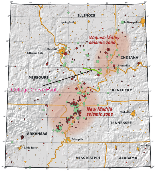
描述 This map of the New Madrid and Wabash Valley seismic zones shows  earthquakes as circles. Red circles indicate earthquakes that occurred from 1974 to  2002 with magnitudes larger than 2.5 located using modern instruments (University  of Memphis). Green circles denote earthquakes that occurred prior to 1974 (USGS  Professional Paper 1527). Larger earthquakes are represented by larger circles. The Cottage Grove Fault is indicated by the green line.
日期 (UTC)
来源
作者


这是一张修改过的图片,这意味着它已在原版本的基础上通过软件进行了编辑,改动内容:Added Cottage Fault。其原始版本为:New Madrid and Wabash seizmic zones-USGS.png。修改者:Ruslik0


Public domain
本图片在美国属于公有领域,因为其只包含最初来自美国内政部下属机构美国地质调查局的材料。更多信息请参见USGS官方版权方针

Bahasa Indonesia  català  čeština  Deutsch  eesti  English  español  français  galego  italiano  Nederlands  português  polski  sicilianu  suomi  Tiếng Việt  Türkçe  български  македонски  русский  മലയാളം  한국어  日本語  中文  中文(简体)  中文(繁體)  العربية  فارسی  +/−

原始上传日志

This image is a derivative work of the following images:

  • File:New_Madrid_and_Wabash_seizmic_zones-USGS.png licensed with PD-USGov-USGS
    • 2008-04-25T02:30:32Z Kbh3rd 748x819 (478218 Bytes) {{Information |Description=This map of the New Madrid and Wabash Valley seismic zones shows  earthquakes as circles. Red circles indicate earthquakes that occurred from 1974 to 

Uploaded with derivativeFX

说明

添加一行文字以描述该文件所表现的内容

此文件中描述的项目

描繪內容

440,546 字节

819 像素

748 像素

e0701860dc3c512941f7b60bb7e9b241f2b29c34

文件历史

点击某个日期/时间查看对应时刻的文件。

日期/时间缩⁠略⁠图大小用户备注
当前2009年6月11日 (四) 12:102009年6月11日 (四) 12:10版本的缩略图748 × 819(430 KB)Ruslik0Improved version
2009年6月11日 (四) 10:132009年6月11日 (四) 10:13版本的缩略图748 × 819(431 KB)Ruslik0{{Information |Description=This map of the New Madrid and Wabash Valley seismic zones shows  earthquakes as circles. Red circles indicate earthquakes that occurred from 1974 to  2002 with magnitudes la

以下页面使用本文件:

全域文件用途

以下其他wiki使用此文件: