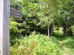
科茨沃尔德之路
外观
| 科茨沃尔德之路 | |
|---|---|
 | |
| 長度 | 164公里(102英里) |
| 地點 | 英格兰 |
| 指定 | 国家小径 |
| 端點 | 格洛斯特郡奇平卡姆登 萨默塞特郡巴斯 |
| 用途 | 远足 |
| 最高點 | 克利夫山, 1,083英尺(330米) [1] |
科茨沃尔德之路(Cotswold Way)是一条102-英里(164-公里)长的小径,路线沿着英格兰科茨沃尔德山区边缘的断崖。它于2007年5月24日正式命名为国家小径[2]。


路线
[编辑]
参考
[编辑]- ^ Cotswold Way. Ramblers' Association. [2017-09-28]. (原始内容存档于2017-09-28).
- ^ Cotswold Way - About this trail. National Trail. [2007-06-20]. (原始内容存档于2013-11-13).
- Cotswold Way (页面存档备份,存于互联网档案馆) Official National Trail Cotswold Way website
- Cotswold Way route relation (页面存档备份,存于互联网档案馆) on OpenStreetMap (页面存档备份,存于互联网档案馆)
- Map of the Cotswold Way indicated in 2 mile sections (页面存档备份,存于互联网档案馆)
- Wall Street Journal article (页面存档备份,存于互联网档案馆)
- The Walking Englishman (页面存档备份,存于互联网档案馆)
- Review of the Cotswold Way (页面存档备份,存于互联网档案馆)
- Pictures, interactive map, and detailed information about the trail characteristics and suitability (页面存档备份,存于互联网档案馆)
