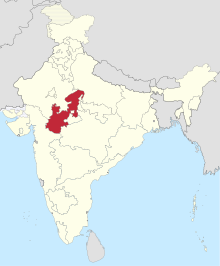
中央邦 (1948年- 1956年)
外观

中央邦(Madhya Bharat)[1]是印度的一个已经撤销的一级行政区,设立于1948年5月28日[2]。中央邦面积46,478平方英里(120,380平方千米)[3]。1956年11月1日,中央邦和温迪亚邦及博帕尔邦合并为新的中央邦。
参考资料
[编辑]- ^ India States. [2021-02-14]. (原始内容存档于2019-04-04).
- ^ Bhind-History. Bhind district website. [2021-02-14]. (原始内容存档于2009-06-19).
- ^ Bhattacharyya, P. K. Historical Geography of Madhya Pradesh from Early Records. Motilal Banarsidass. 1977: 53–4 [2021-01-15]. ISBN 9788120833944. (原始内容存档于2022-01-15).
