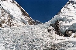
坤布冰河
外观
| 坤布冰河 Khumbu Glacier | |
|---|---|
 坤布冰河与西谷交界的冰瀑。 | |
| 国家 | |
坤布冰河(英语:Khumbu Glacier)是尼泊尔索卢坤布县的一条高山冰川,发源自世界最高峰圣母峰与第四高峰洛子峰之山块,源流海拔约7600公尺,冰河末端海拔则有约4900公尺,[1],是世界海拔最高的冰河[2]。冰河河岸为圣母峰基地营之所在,上游的西冰斗是由基地营通往圣母峰与洛子峰的主要攀登路线之一[3]。
在21世纪时受到全球暖化危机影响,坤布冰河的融冰池塘面积不断地扩大,冰块的温度较前亦有升高[4]。

资料来源
[编辑]- ^ Nepa Maps (Pvt.Ldt. ), NE517: Everest Base Camp & Gokyo, Kathmandu, Nepal, 2013
- ^ ASTER measurement of supraglacial lakes in the Mount Everest region of the Himalaya: The main Khumbu Glacier is about 17 km long with elevations ranging from 4900m at the terminus to 7600m at the source....The 7600m to 8000m elevations are also depicted on numerous detailed topographic maps. [2008-11-24]. (原始内容存档于2011-06-07).
- ^ The Khumbu Glacier. [2010-05-29]. (原始内容存档于2011-07-07).
- ^ 纳文·辛格·卡达. 珠峰冰融新恐怖:長眠冰雪的遺體暴露荒野. BBC 中文网. 2019-03-26 [2019-05-29]. (原始内容存档于2019-05-27) (中文).
27°58′N 86°50′E / 27.967°N 86.833°E
| 这是一篇与尼泊尔地理相关的小作品。您可以通过编辑或修订扩充其内容。 |


