奇彭代爾 (新南威爾士州)
外觀
| 奇彭代爾 Chippendale | |
|---|---|
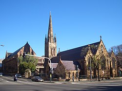
 聖本篤堂及聖母大學 | |
| 坐標:33°53′10″S 151°12′01″E / 33.8861°S 151.2003°E | |
| 國家 | |
| 一級行政區 | 新南威爾士州 |
| 地方政府區域 | 悉尼市 |
| 面積 | |
| • 總計 | 0.7 平方公里(0.3 平方英里) |
| 人口(2016年普查)[1] | |
| • 總計 | 8,617人 |
| 郵政編碼 | 2008 |
| 位置 | 2公里(1.2英里) (距悉尼中心商業區南方) |
| 城市 | 悉尼 |
| 州選區 | 新鎮選舉區 |
| 聯邦選區 | 悉尼 |
33°53′11″S 151°12′00″E / 33.8863°S 151.1999°E奇彭代爾(英語:Chippendale)位於澳大利亞新南威爾士州,緊貼悉尼中心商業區南端的近郊地區。
歷史
[編輯]威廉·奇彭代爾(William Chippendale)於1819年獲授予95英畝(38公頃)延伸至現今的雷德芬火車站的土地。奇彭代爾於1821年以380鎊將之售予商人所羅門·利維(Solomon Levey)。1833年,利維在倫敦逝世。土地輾轉落入威廉·哈欽森(William Hutchinson)之手。[2][3]

奇彭代爾有多個已列入遺產名錄的建築物,包括又名停屍間站(Mortuary Station)的攝政街火車站和紀念前新南威爾士州長約翰·斯托里的約翰·斯托里紀念藥房。
舊區重建
[編輯]有168年歷史的卡爾頓聯合啤酒廠於2006年12月停運,其所在的5.8公頃地皮獲重新規劃,並發展為大約255,000平方公尺的商住項目中央公園一號[4]。
參考
[編輯]- ^ Australian Bureau of Statistics. Chippendale (State Suburb). 2016 Census QuickStats. 27 June 2017 [2017-07-02].
- ^ The Book of Sydney Suburbs, Compiled by Frances Pollen, Angus & Robertson Publishers, 1996, Published in Australia ISBN 0-207-19007-0
- ^ Libraries Australia. Part of Chippendale's grant. http://nla.gov.au/anbd.bib-an000040747752 (頁面存檔備份,存於網際網路檔案館)
- ^ Archived copy. [2009-01-25]. (原始內容存檔於2009-02-07).
延伸閱讀
[編輯]- Shirley Fitzgerald. CHIPPENDALE - Beneath The Factory Wall. Published by Halstead Press, Australia. 2008. (ISBN 9781920831486).
外部連結
[編輯]- Fitzgerald, Shirley. Chippendale. Dictionary of Sydney. 2008 [2015-09-26]. (原始內容存檔於2021-02-09). [CC-By-SA]


