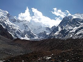
阿比峰
外觀
| Api | |
|---|---|
 Approached from the Mahakali Khola, the southern/western aspects of Api. | |
| 最高點 | |
| 海拔 | 7,132米(23,399英尺)[1][2] |
| 地形突起度 | 2,040米(6,690英尺)[1] |
| 座標 | 30°00′15″N 80°56′00″E / 30.00417°N 80.93333°E |
| 地理 | |
| 國家 | |
| 區 | Darchula District |
| 所屬山脈 | Yoka Pahar Subsection,Gurans Himal,喜馬拉雅山脈 |
| 攀山 | |
| 首次登頂 | 1960年5月10日 K. Hirabayashi,Gyaltsen Norbu |
| 最簡路線 | rock/snow/ice climb |
阿比峰是尼泊爾的山峰,毗鄰與印度和西藏接壤的邊境,屬於喜馬拉雅山脈的一部分,海拔高度7,132米,日本攀山隊在1960年5月10日首次登上該山峰。
參考
[編輯]- ^ 1.0 1.1 Ultra-prominent peaks of Nepal. peaklist.org. [6 January 2009]. (原始內容存檔於25 December 2008).
- ^ Himalayan Index. Alpine Club. [2009-12-24]. (原始內容存檔於2017-07-17).
| 這是一篇與尼泊爾地理相關的小作品。您可以透過編輯或修訂擴充其內容。 |

