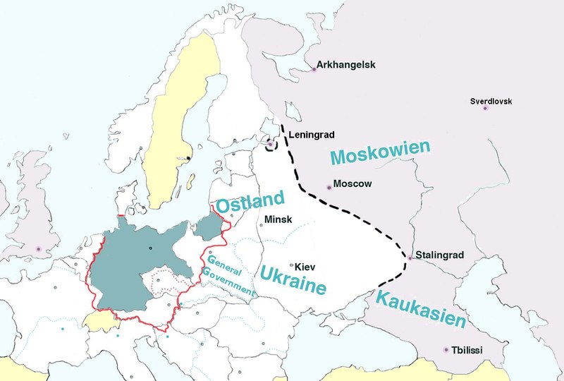
File:Generalplan Ost map.tiff
外觀

此 TIF 檔案的 JPG 預覽的大小:800 × 540 像素。 其他解析度:320 × 216 像素 | 640 × 432 像素 | 1,024 × 691 像素 | 1,166 × 787 像素。
原始檔案 (1,166 × 787 像素,檔案大小:2.63 MB,MIME 類型:image/tiff)
檔案歷史
點選日期/時間以檢視該時間的檔案版本。
| 日期/時間 | 縮圖 | 尺寸 | 用戶 | 備註 | |
|---|---|---|---|---|---|
| 目前 | 2017年2月9日 (四) 17:22 |  | 1,166 × 787(2.63 MB) | Claude Zygiel | Leningrad |
| 2017年2月9日 (四) 17:18 |  | 1,166 × 787(2.63 MB) | Claude Zygiel | Sverdlovsk, Tbilissi, borders during the war in green, neutral states in yellow | |
| 2016年7月28日 (四) 17:35 |  | 1,166 × 787(2.63 MB) | Julieta39 | Pre-WW2 borders in grey, Gross-Deutschlands Reich in red, add General-Government | |
| 2011年4月10日 (日) 19:07 |  | 1,166 × 787(2.63 MB) | Lihagen | {{Information |Description ={{en|1=Map of Europe, with pre-WW2 boarders, showing the extension of Nazi Germany's GENERALPLAN OST. Legend: Dark grey – Germany (Deutsches Reich); Dotted black line – the extension of a second ”phase of resattlemen |
檔案用途
下列頁面有用到此檔案:
全域檔案使用狀況
以下其他 wiki 使用了這個檔案:
- ar.wikipedia.org 的使用狀況
- cs.wikipedia.org 的使用狀況
- da.wikipedia.org 的使用狀況
- el.wikipedia.org 的使用狀況
- en.wikipedia.org 的使用狀況
- es.wikipedia.org 的使用狀況
- et.wikipedia.org 的使用狀況
- fr.wikipedia.org 的使用狀況
- he.wikipedia.org 的使用狀況
- id.wikipedia.org 的使用狀況
- it.wikipedia.org 的使用狀況
- ja.wikipedia.org 的使用狀況
- mk.wikipedia.org 的使用狀況
- nl.wikipedia.org 的使用狀況
- no.wikipedia.org 的使用狀況
- ro.wikipedia.org 的使用狀況
- ru.wikipedia.org 的使用狀況
- sh.wikipedia.org 的使用狀況
- sk.wikipedia.org 的使用狀況
- sr.wikipedia.org 的使用狀況
- sv.wikipedia.org 的使用狀況
- uk.wikipedia.org 的使用狀況

