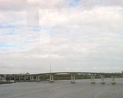
勝利橋 (新澤西州)
外觀
| Bob Graham Sunshine Skyway Bridge | |
|---|---|
 從愛迪生橋上看勝利橋 | |
| 座標 | 40°30′28″N 74°17′31″W / 40.50778°N 74.29194°W |
| 承載 | 35號新澤西州州道雙向四車道,再加非機動車道/行人路 |
| 跨越 | 拉里坦河 |
| 地點 | 新澤西州米德爾塞克斯縣Sayreville和Perth Amboy之間 |
| 維護單位 | New Jersey Department of Transportation |
| 設計參數 | |
| 橋型 | segmental precast concrete |
| 歷史 | |
| 開通日 | 1926(第一代勝利橋,拆毀於2004年) 2004年6月8日(第二代勝利橋) |
| 地圖 | |
 | |
勝利橋(英語:Victory Bridge)是美國新澤西州的一個跨過拉里坦河的橋樑,位於米德爾塞克斯縣,是35號新澤西州州道的過河通道。[1]
參考文獻
[編輯]- ^ Lettiere announces completion of Route 35 Victory Bridge and Victory Circle Project 互聯網檔案館的存檔,存檔日期2006-12-06., New Jersey Department of Transportation press release dated October 27, 2005. "The original Route 35 Victory Bridge was built in 1926, connecting the municipalities of Perth Amboy City and Sayreville Borough in Middlesex County. The 360-foot structure was the longest swing span bridge in New Jersey at the time it was built. The original bridge was commemorated to World War I veterans of New Jersey."
外部連結
[編輯]- Historic American Engineering Record (HAER) No. NJ-120, "Victory Bridge" (old bridge)
- Victory Bridge construction update (頁面存檔備份,存於互聯網檔案館)
- Success Story: New Jersey Goes Precast for Victory Bridge (頁面存檔備份,存於互聯網檔案館)
